58k+ listingsShips to NLResponse within one hour+31 73 711 4717info@questpair.com
Procurable · sourced on request

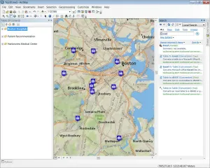
Esri ArcGIS 10.2

UsedEsriData acquisitionNetherlands
Procurable

Not in stock, available to order through our sourcing team

Not in stock, but we can get it for you

We source this model through our supplier network. Request a quote and we'll come back within one hour.

  1. Request a quote
  2. We confirm price and lead time
  3. You approve, we ship to you
CPU Speed
2.2 GHz minimum
Processor
Intel Pentium 4, Intel Core Duo, or Xeon processors; SSE2 minimum
Memory/RAM
2 GB minimum
Display Properties
24-bit color depth
Screen Resolution
1024 x 768 recommended minimum at normal size (96 dpi)
Availability
Procurable
Lead time
Confirmed with your quote
All 19 specifications
  • Ships to NL
  • Response within 1 hour
  • Warranty available. Buy without worry
  • Support from a scientist

Specifications 19

Brands
Esri
New/Used
Used
CPU Speed
2.2 GHz minimum
Processor
Intel Pentium 4, Intel Core Duo, or Xeon processors; SSE2 minimum
Memory/RAM
2 GB minimum
Display Properties
24-bit color depth
Screen Resolution
1024 x 768 recommended minimum at normal size (96 dpi)
Swap Space
500 MB minimum
Disk Space
2.4 GB minimum
Video/Graphics Adapter
64 MB RAM minimum, 256 MB RAM or higher recommended; NVIDIA, ATI, and Intel chipsets supported; 24-bit capable graphics accelerator; OpenGL version 2.0 runtime minimum required, Shader Model 3.0 or higher recommended
Networking Hardware
Simple TCP/IP, Network Card, or Microsoft Loopback Adapter required for the license manager
Operating System
Windows 8.1 Basic, Professional, and Enterprise (64 bit [EM64T]); Windows 8 Basic, Professional, and Enterprise (64-bit [EM64T]); Windows 7 Ultimate, Enterprise, Professional, Home Premium (64-bit [EM64T]); Windows Vista Ultimate, Enterprise, Business, Home Premium (64-bit [EM64T]) Version: min SP1 max SP2; Windows Server 2012 R2 Standard, and Datacenter (64 bit [EM64T]); Windows Server 2012 Standard, and Datacenter (64 bit [EM64T]); Windows 2008 Server Standard, Enterprise & Datacenter (64-bit [EM64T]) Version: max SP2; Windows 2008 R2 Server Standard, Enterprise & Datacenter (64-bit [EM64T])
Python Requirement for Geoprocessing
ArcGIS for Desktop geoprocessing tools require that Python 2.7.x and Numerical Python 1.6.x are installed
Internet Explorer Requirement
Microsoft Internet Explorer, minimum 7 or 8, must be installed prior to installing ArcGIS for Desktop; Internet Explorer 9, 10, and 11 are also supported
Real-Time Data Processing
ArcGIS GeoEvent Processor for Server extension enables users to connect with streaming data sources, perform real-time analysis, and trigger alerts based on specific conditions
Web GIS Capabilities
Integration with ArcGIS Online allows for the creation, sharing, and collaboration of web maps, extending GIS accessibility across organizations
3D Visualization Enhancements
Ability to export ArcScene documents to 3D web scenes enables users to share complex 3D data through web browsers
Availability
Procurable
Lead time
Confirmed with your quote

Product description

GIS software with real-time data processing, advanced spatial analysis, web GIS, and enhanced 3D visualization features.

ArcGIS 10.2 is a comprehensive geographic information system (GIS) software suite developed by Esri, released in July 2013. This version introduced significant enhancements to facilitate real-time data integration, web-based GIS deployment, and advanced spatial analysis, making it a pivotal tool for professionals across various scientific and industrial domains.

Key features include:

  • Real-time data processing: The introduction of the ArcGIS GeoEvent Processor for Server extension enables users to connect with streaming data sources, perform real-time analysis, and trigger alerts based on specific conditions.
  • Enhanced web GIS capabilities: Integration with ArcGIS Online allows for the creation, sharing, and collaboration of web maps, extending GIS accessibility across organizations.
  • Advanced spatial analysis tools: New online analysis tools facilitate the investigation of geographic relationships, patterns, and trends within data, including overlay layers and hot-spot analysis.
  • Improved data interoperability: Support for additional data formats, such as U.S. Census Bureau TIGER/GML and Google Spreadsheet, enhances data integration and sharing capabilities.
  • 3D visualization enhancements: The ability to export ArcScene documents to 3D web scenes enables users to share complex 3D data through web browsers, facilitating better communication of spatial information.

ArcGIS 10.2 is widely utilized in fields such as environmental science, urban planning, public health, and biotechnology. In the biotechnology sector, it supports applications like epidemiological mapping, genomic data visualization, and facility site selection, providing critical spatial insights for research and development.

Commonly adopted by academic institutions, government agencies, biotech companies, and research organizations, ArcGIS 10.2 remains a valuable tool for spatial analysis and decision-making. While newer versions have been released, this version continues to be relevant in various settings due to its robust features and capabilities.

Why Questpair exists

Lab equipment markets are fragmented. Buyers spend weeks calling distributors, comparing quotes, and verifying supplier reliability. Sellers struggle to reach global research labs.

We built Questpair to fix this. Every supplier on the platform is verified before listing. Every quote you receive comes from a real, vetted seller. AI prepares your case in minutes, then a real specialist takes over.

We're an independent team based in The Netherlands, working with research labs and procurement teams across Europe and worldwide.

Frequently asked questions

How long does laboratory equipment typically last?

With a service contract, ten to fifteen years is normal for most benchtop instruments. Detectors and pumps are the parts that wear first.

Can I get service for older equipment?

Often, yes. Verified suppliers frequently work with service partners converting the instrument. If applicable, we can list servicing options alongside the offer.

Where can I buy parts?

Ask a scientist through the request button. Parts are often available even when the instrument itself is discontinued.

What is the typical lead time for refurbished equipment?

Two to six weeks, depending on refurbishment scope and whether calibration is included.

Does laboratory equipment ship internationally?

We ship to 38 countries. Crating and customs handling are quoted with the instrument.

Reply in one hour

Can't find the exact configuration?

Tell us what you need and a scientist finds it for you, usually within the hour.

Last updated 23 October 2026